'%3e%3cpath%20d='M27.3241%207.13598H19.5178V5.5278H25.9676C23.2162%202.69109%2019.3643%200.925079%2015.1007%200.929344C6.75266%200.937876%20-0.00852339%207.71185%208.06505e-06%2016.0599C0.00427379%2020.155%201.64018%2023.8662%204.28706%2026.5856C4.07591%2026.2763%203.92661%2025.9542%203.83276%2025.6492C3.6792%2025.1203%203.6792%2024.7449%203.66213%2023.2434V16.0599H5.91444V23.4652C5.91444%2023.9771%205.89738%2024.4719%206.06801%2024.9326C6.5287%2026.0929%207.79136%2026.2294%208.508%2026.2294C8.86632%2026.2294%209.77066%2026.2123%2010.4361%2025.6322C11.1016%2025.035%2011.1016%2024.3525%2011.1016%2023.3457V16.0599H13.3709V23.6529C13.3539%2025.0179%2013.3539%2026.1441%2012.0741%2027.2361C10.8456%2028.311%209.25877%2028.4134%208.43975%2028.4134C7.70604%2028.4134%206.9894%2028.3281%206.30689%2028.0892C6.02535%2027.9911%205.77154%2027.8738%205.53905%2027.7394C8.14968%2029.8787%2011.4897%2031.1627%2015.1284%2031.1606C23.4764%2031.152%2030.2355%2024.378%2030.2291%2016.03C30.2248%2012.7049%2029.1456%209.63143%2027.322%207.13811L27.3241%207.13598ZM26.6181%2015.1897L25.6541%2013.8161C25.9762%2013.605%2026.9786%2012.9502%2026.9786%2011.1074C26.9786%2010.7981%2026.953%2010.476%2026.8293%2010.1668C26.5691%209.53545%2026.1255%209.42454%2025.8269%209.42454C25.2702%209.42454%2025.0718%209.80846%2024.9609%2010.0793C24.8863%2010.2777%2024.8735%2010.3011%2024.6879%2011.0946L24.4661%2012.1461C24.3296%2012.7028%2024.2677%2012.9758%2024.1568%2013.2466C23.9969%2013.6433%2023.4636%2014.7183%2022.0176%2014.7183C20.3603%2014.7183%2019.296%2013.3213%2019.296%2011.2673C19.296%209.38615%2020.2238%208.37304%2021.0642%207.75451L22.0666%209.08968C21.6336%209.38615%2020.7677%209.95562%2020.7677%2011.3526C20.7677%2012.2314%2021.1644%2012.9971%2021.832%2012.9971C22.5742%2012.9971%2022.7235%2012.1802%2022.8707%2011.3889L23.0691%2010.4867C23.3165%209.3115%2023.7985%207.65426%2025.6669%207.65426C27.6718%207.65426%2028.4759%209.50985%2028.4759%2011.3654C28.4759%2011.8475%2028.4268%2012.3914%2028.2775%2012.9246C28.1047%2013.5068%2027.6824%2014.5327%2026.6203%2015.1875L26.6181%2015.1897Z'%20fill='black'/%3e%3c/g%3e%3cdefs%3e%3cclipPath%20id='clip0_0_115'%3e%3crect%20width='30.2291'%20height='30.2291'%20fill='white'%20transform='translate(0%200.929443)'/%3e%3c/clipPath%3e%3c/defs%3e%3c/svg%3e)


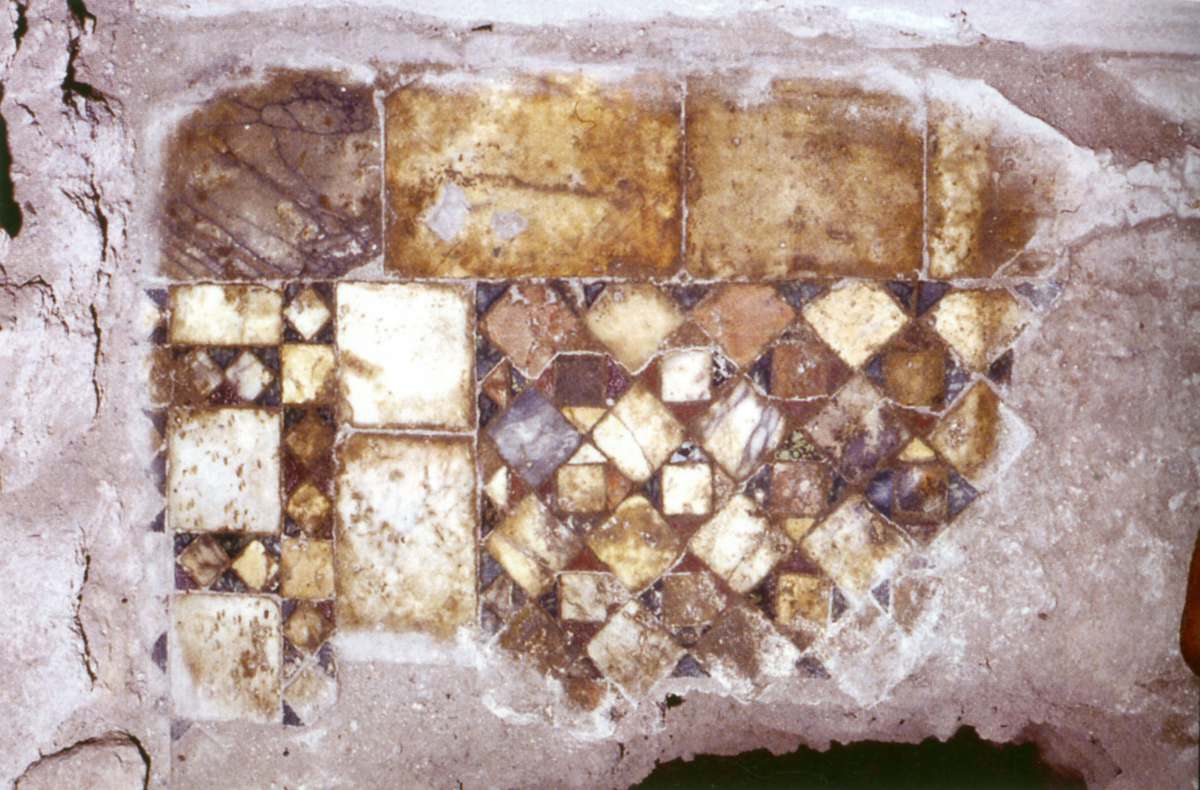
The present S. Omobono church, rebuilt in 1482, is a hall church that was once north-facing and is today south-facing. From the medieval complex, remains of a Cosmatesque floor and the foundations of the presbytery attributable to the time of Pope Paschal II (1099-1118) were found in an excavation within the perimeter walls of the cella of an ancient temple a few metres below the present building. The bell tower (demolished in 1937) may also date back to the 12th century.
 Download
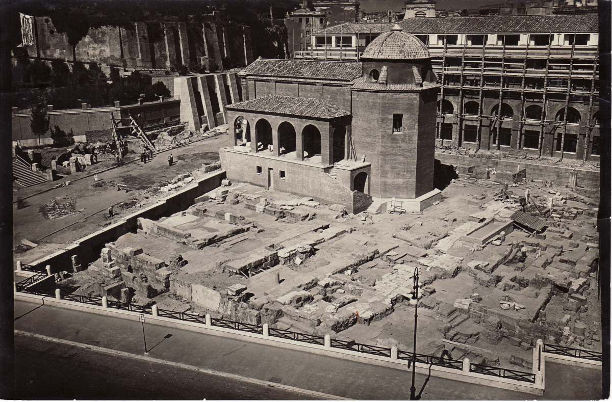
Rom, Area sacra di S. Omobono (Foto nach 1936, Terrenato et al. 2012)
BY-NC-SA 4.0
 Download
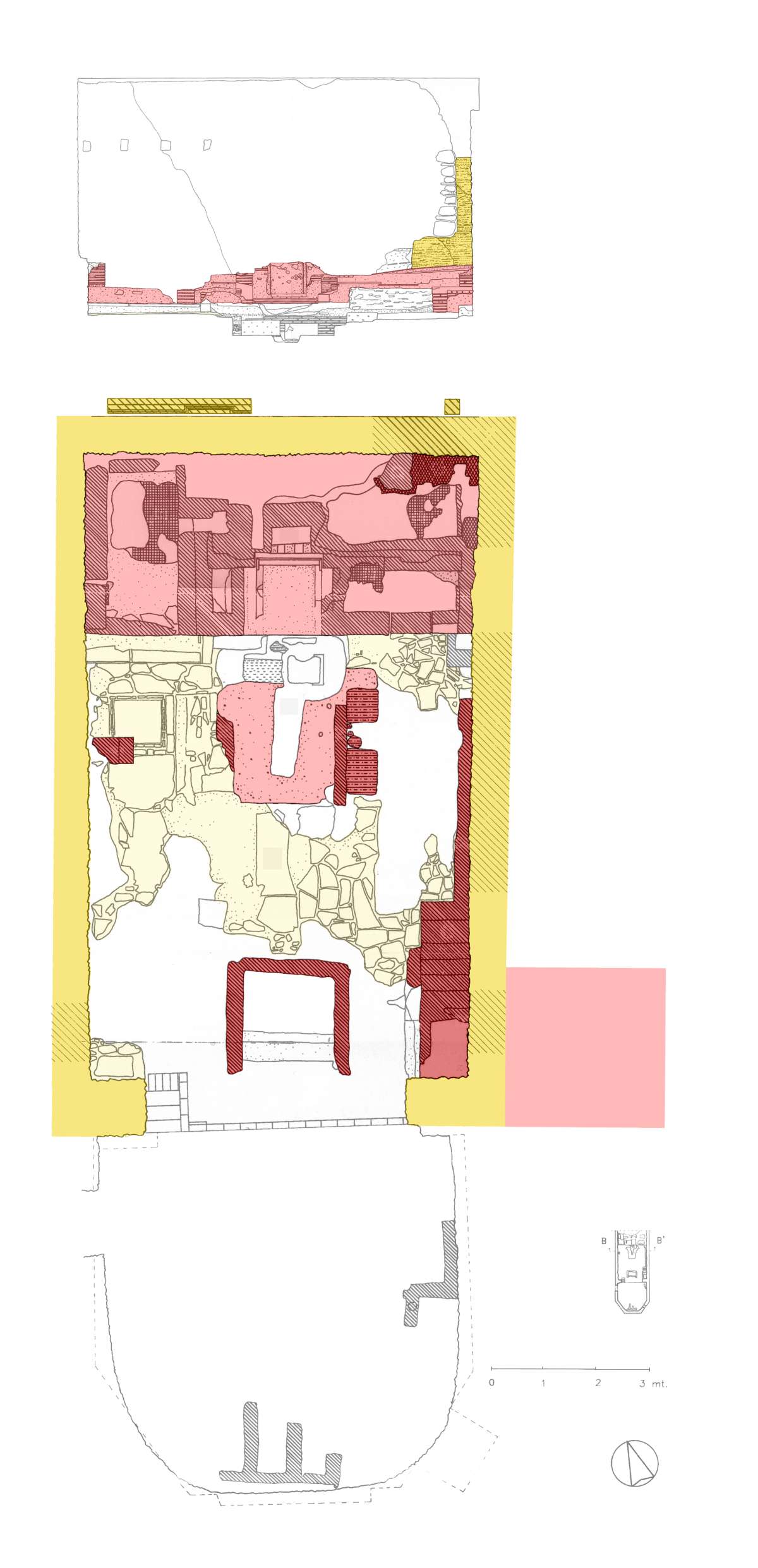
Rom, Area sacra di S. Omobono, Grabungsplan (nach Terrenato et al. 2012)
BY-NC-SA 4.0
 Download
Rom, S. Omobono, Reste des mittelalterlichen Campaniles von Süden, Foto vor 1936 (Fotothek BHR)
BY-NC-SA 4.0
 Download
Rom, S. Omobono, Grabungsplan des Innenraums mit Ausstattungsphasen und Querschnitt (aus Ramieri 2002, nach Giustini, überarbeitet von D. Pedroli)
BY-NC-SA 4.0
 Download
Rom, S. Omobono, Fragment des Cosmatenpaviments im Presbyterium (nach Ramieri 2011)
BY-NC-SA 4.0
 Download
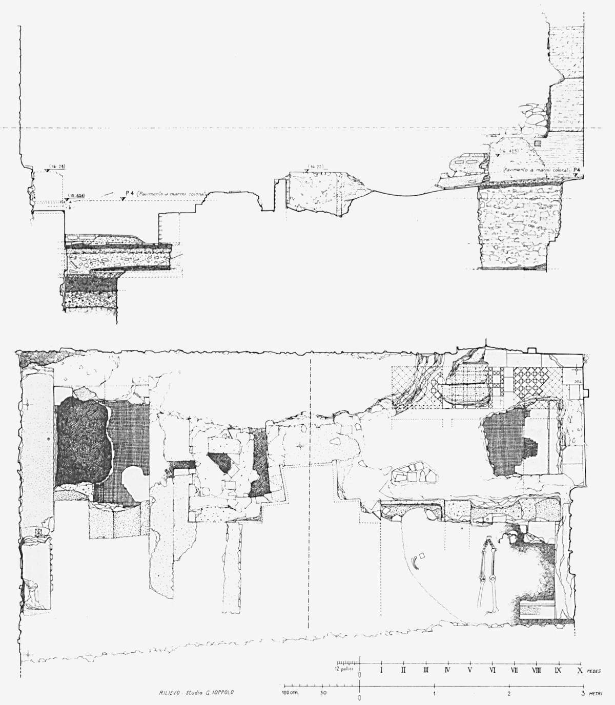
Rom, S. Omobono, Grabungsplan und Querschnitt des Presbyteriums (nach Ioppolo 1985)
BY-NC-SA 4.0
 Download
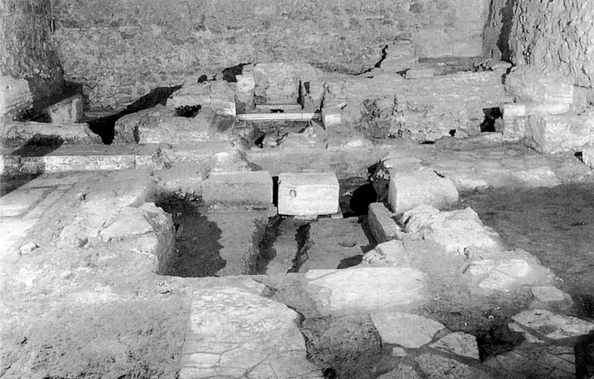
Rom, S. Omobono, Ansicht des Presbyteriums (nach Ramieri 2002)
BY-NC-SA 4.0
- Number in map
- 82
- Church name
- S. Omobono
- Existing
- Coordinates
- 41.89096, 12.48138
- Address
- Vico Jugario
- Rione
- Ripa (XII)
- Nolli's map #
- 1046
- Chronology
- 12th century
- Keywords
- hall church, bell tower, cosmatesque pavement, Pope Paschal II
- Research status
- Completed
- Published in
Corpus Cosmatorum II, volume 4
- Authors
- Klein, Almuth
2D